Dataja:Bundesarchiv Bild 183-Z0309-310, Zerstörtes Dresden.jpg
Wuše wótgranicowanje njeeksistěrujo.
Bundesarchiv_Bild_183-Z0309-310,_Zerstörtes_Dresden.jpg (795 × 537 pikselow, wjelikosć dataje: 314 kB, MIME-Typ: image/jpeg)
Zespominanje
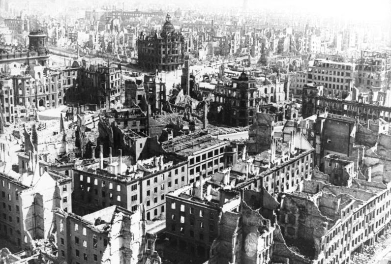
| Dresden, Zerstörungen
( |
|||||||||||||||||||||||||||
|---|---|---|---|---|---|---|---|---|---|---|---|---|---|---|---|---|---|---|---|---|---|---|---|---|---|---|---|
| Fotograf |
Beyer, G. |
||||||||||||||||||||||||||
| Titel |
Dresden, Zerstörungen |
||||||||||||||||||||||||||
| Original-Bildunterschrift |
For documentary purposes the German Federal Archive often retained the original image captions, which may be erroneous, biased, obsolete or politically extreme. ADN-ZB/G. Beyer
Dresden 1945: Blick vom Rathausturm auf die zerstörte Stadt. Im Vordergrund der heutige Pirnaische Platz. |
||||||||||||||||||||||||||
| Zwobraznjene městno | Drježdźany | ||||||||||||||||||||||||||
| Datum | 1945 | ||||||||||||||||||||||||||
| Sammlung |
|
||||||||||||||||||||||||||
| Aktualne městno |
Allgemeiner Deutscher Nachrichtendienst - Zentralbild (Bild 183) |
||||||||||||||||||||||||||
| Inwentarowe čisło | |||||||||||||||||||||||||||
| Žrědło |
|
||||||||||||||||||||||||||

| Pozicija kamery | | Tónle a dalše wobrazy pola: OpenStreetMap |
|---|
Licencěrowanje
Diese Datei ist unter der Creative-Commons-Lizenz „Namensnennung – Weitergabe unter gleichen Bedingungen 3.0 Deutschland“ lizenziert.
Pśipokazanje: Bundesarchiv, Bild 183-Z0309-310 / G. Beyer / CC-BY-SA 3.0
- Smějoš:
- gromaźe wužywaś – źěło kopěrowaś, rozšyriś a dalej daś
- změšaś – aby źěło pśiměrił
- Pód slědujucymi wuměnjenjami:
- pśipokazanje – Musyš źěło pó wašni pśipokazaś, kótaruž awtor abo licencowaŕ jo pódał (ale nic pó wašni, až by se gódało, až wón tebje abo twójo wužywanje źěła schwalijo).
- źěliś – Jolic měnjaš, pśetworjaš toś to źěło abo na njo natwarjaš, móžoš gótowe źěło jano pód teju sameju licencu ako toś ta rozšyriś.

| Annotations | This image is annotated: View the annotations at Commons |
| Pozicija objekta | | Tónle a dalše wobrazy pola: OpenStreetMap |
|---|
Stawizny dataje
Tłoc na datum/cas aby tencasna wersija se lodowała.
| datum/cas | Pśeglědowy wobraz | rozměry | Wužywaŕ | Komentar | |
|---|---|---|---|---|---|
| něntejšny | 30. januara 2012, 12:23 | | 795x537 (314 kB) | AndreasPraefcke | Reverted to version as of 20:21, 5 December 2008 |
| 15. januara 2012, 10:38 |  | 796x538 (154 kB) | Jakuzem | Reduced file size by selecting higher compression (90 %). Original image used as a source. | |
| 5. decembra 2008, 22:21 |  | 795x537 (314 kB) | Greenshed | slight crop to remove irregular border | |
| 5. decembra 2008, 22:16 |  | 800x537 (242 kB) | Greenshed | removing caption | |
| 4. decembra 2008, 20:43 |  | 800x560 (105 kB) | BArchBot | == Summary == {{Information |Description={{BArch-description|1='''Zerstörtes Dresden''' ADN-ZB/G. Beyer Dresden 1945: Blick vom Rathausturm auf die zerstörte Stadt. Im Vordergrund der heutige Pirnaische Platz. }} |Source=Deutsches Bundesarchiv (German |
Datajowe wužywanje
Slědujucy bok wótkazujo na toś tu dataju:
Globalne wužywanje datajow
Slědujuce druge wikije wužywaju toś ten wobraz:
- Wužywanje na azb.wikipedia.org
- Wužywanje na cs.wikipedia.org
- Wužywanje na cv.wikipedia.org
- Wužywanje na cy.wikipedia.org
- Wužywanje na da.wikipedia.org
- Wužywanje na de.wikipedia.org
- 13. Februar
- Diskussion:Deutschland/Archiv/1
- Portal:Imperialismus und Weltkriege/Exzellente Artikel
- Pirnaischer Platz
- Luftangriffe auf Dresden
- Diskussion:Deutschland/Archiv/2
- Kaiserpalast (Dresden)
- Diskussion:Grunaer Straße
- Portal:Dresden/Galerie der Besten
- Theodor Buhl
- Wikipedia Diskussion:Hauptseite/Artikel des Tages/Archiv/Vorschläge/2020/Q1
- Wikipedia:Hauptseite/Archiv/13. Februar 2020
- Benutzer Diskussion:Недєляєва Дар'я
- Wužywanje na de.wikibooks.org
- Wužywanje na de.wikinews.org
- Wužywanje na de.wiktionary.org
- Wužywanje na en.wikipedia.org
- Wužywanje na eo.wikipedia.org
- Wužywanje na es.wikipedia.org
- Wužywanje na fa.wikipedia.org
- Wužywanje na fi.wikipedia.org
- Wužywanje na fr.wikipedia.org
- Wužywanje na he.wikipedia.org
- Wužywanje na hr.wikipedia.org
- Wužywanje na hsb.wikipedia.org
- Wužywanje na hu.wikipedia.org
- Wužywanje na id.wikipedia.org
- Wužywanje na it.wikipedia.org
- Wužywanje na ka.wikipedia.org
- Wužywanje na ko.wikipedia.org
Dalšne globalne wužywanje toś teje dataje pokazaś.