Dataja:Klimagürtel-der-erde-tropen.png

Wjelikosć toś togo pśeglěda: 800 × 400 pikselow. Druge rozeznaśa: 320 × 160 pikselow | 640 × 320 pikselow | 1.024 × 512 pikselow | 1.280 × 640 pikselow | 3.600 × 1.800 pikselow.
Originalna dataja (3.600 × 1.800 pikselow, wjelikosć dataje: 685 kB, MIME-Typ: image/png)

|
Dieses Bild des Typs Meteorology sollte als Vektorgrafik im SVG-Format neu erstellt werden. Vektorformate haben zahlreiche Vorteile; weitere Information unter Commons:Media for cleanup. Wenn dir eine SVG-Version dieses Bildes vorliegt, so lade diese bitte hoch. Nach dem Hochladen der Datei ist diese Vorlage auf der aktuellen Bildbeschreibungsseite durch die Vorlage {{Vector version available}}, oder kürzer {{Vva}}, zu ersetzen. Es ist empfohlen die neue SVG-Datei „Klimagürtel-der-erde-tropen.svg“ zu nennen – dann benötigt die Vorlage vector version available (bzw. vva) keinen Parameter.
|
Zespominanje
| wopis |
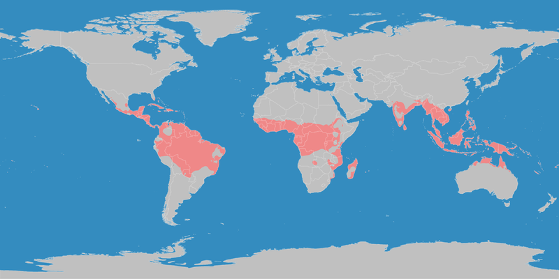
English: This map shows the Earth zones with tropical climate. Deutsch: Diese Karte stellt die tropische Klimazone der Erde dar. |
| Datum | |
| Žrědło |
English: Own work on the basis of the following data: Deutsch: Selbst erstellt auf Basis dieser Geodaten:
|
| Awtor | LordToran |
| Dowolenje (dalewužiwanje tuteje dataje) |
|
| Druge wersije toś teje dataje |
 |
Licencěrowanje
Toś ta dataja jo pód licencu Creative Commons Attribution-Share Alike 3.0 Unported licencěrowana
- Smějoš:
- gromaźe wužywaś – źěło kopěrowaś, rozšyriś a dalej daś
- změšaś – aby źěło pśiměrił
- Pód slědujucymi wuměnjenjami:
- pśipokazanje – Musyš źěło pó wašni pśipokazaś, kótaruž awtor abo licencowaŕ jo pódał (ale nic pó wašni, až by se gódało, až wón tebje abo twójo wužywanje źěła schwalijo).
- źěliś – Jolic měnjaš, pśetworjaš toś to źěło abo na njo natwarjaš, móžoš gótowe źěło jano pód teju sameju licencu ako toś ta rozšyriś.
Stawizny dataje
Tłoc na datum/cas aby tencasna wersija se lodowała.
| datum/cas | Pśeglědowy wobraz | rozměry | Wužywaŕ | Komentar | |
|---|---|---|---|---|---|
| něntejšny | 11. oktobra 2016, 23:13 | | 3.600x1.800 (685 kB) | Maphobbyist | The Caspian Sea was omitted. The Köppen system is based on the concept that climate types are correlated with the natural vegetation. |
| 15. oktobra 2007, 17:26 |  | 3.600x1.800 (585 kB) | Lortordermur | ||
| 5. junija 2007, 22:49 |  | 3.445x1.731 (628 kB) | Lortordermur | == Beschreibung == {{Information |Description=Diese Karte stellt die tropische Klimazone der Erde dar. |Source=Selbst erstellt auf Basis [http://www.copernicus.org/EGU/hess/hessd/4/439/hessd-4-439.htm dieser Karte], welche unter einer Creative-Commons-Li |
Datajowe wužywanje
Slědujucy bok wótkazujo na toś tu dataju:
Globalne wužywanje datajow
Slědujuce druge wikije wužywaju toś ten wobraz:
- Wužywanje na als.wikipedia.org
- Wužywanje na de.wikiversity.org
- Wužywanje na en.wikipedia.org
- Wužywanje na en.wikivoyage.org
- Wužywanje na fy.wikipedia.org
- Wužywanje na hsb.wikipedia.org
- Wužywanje na ja.wikipedia.org
- Wužywanje na ko.wikipedia.org
- Wužywanje na mk.wikipedia.org
- Wužywanje na nl.wikipedia.org
- Wužywanje na ro.wikipedia.org
- Wužywanje na sr.wikipedia.org
- Wužywanje na sv.wikipedia.org
- Wužywanje na tr.wikipedia.org
- Wužywanje na vi.wikipedia.org
- Wužywanje na zh.wikipedia.org