Dataja:LDDyfedCantrefi.png

Wjelikosć toś togo pśeglěda: 800 × 571 pikselow. Drugej rozeznaśi: 320 × 228 pikselow | 640 × 457 pikselow | 1.024 × 731 pikselow | 1.344 × 959 pikselow.
Originalna dataja (1.344 × 959 pikselow, wjelikosć dataje: 61 kB, MIME-Typ: image/png)
Zespominanje
| wopis |
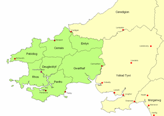
English: Map of ancient Dyfed, showing its position in southwest Wales, various important medieval towns, and its 7 cantrefs. |
| Datum | 1. oktobra 2007 (Original-Hochladedatum) |
| Žrědło | Übertragen aus en.wikipedia nach Commons. |
| Awtor | LinguisticDemographer auf Wikipedija auf engelšćina |
Licencěrowanje
| Dieses Werk wurde von seinem Urheber LinguisticDemographer auf Wikipedija auf engelšćina als gemeinfrei veröffentlicht. Dies gilt weltweit. W někotrych krajach je to snano prawnisce njemóžno; jeli tomu tak je: LinguisticDemographer gewährt jedem das bedingungslose Recht, dieses Werk für jedweden Zweck zu nutzen, es sei denn, Bedingungen sind gesetzlich erforderlich. |
Originalny protokol nagraśow
Die ursprüngliche Dateibeschreibungsseite war hier. Alle folgenden Benutzernamen beziehen sich auf en.wikipedia.
- 2007-10-01 20:53 LinguisticDemographer 1344×959×8 (62009 bytes) Map of ancient Dyfed, showing its position in southwest Wales, various important medieval towns, and its 7 cantrefs.
Stawizny dataje
Tłoc na datum/cas aby tencasna wersija se lodowała.
| datum/cas | Pśeglědowy wobraz | rozměry | Wužywaŕ | Komentar | |
|---|---|---|---|---|---|
| něntejšny | 19. februara 2008, 18:15 | | 1.344x959 (61 kB) | File Upload Bot (Magnus Manske) | {{BotMoveToCommons|en.wikipedia}} {{Information |Description={{en|Map of ancient Dyfed, showing its position in southwest Wales, various important medieval towns, and its 7 cantrefs.}} |Source=Transferred from [http://en.wikipedia.org en.wikipedia] |Date |
Datajowe wužywanje
Slědujucy bok wótkazujo na toś tu dataju:
Globalne wužywanje datajow
Slědujuce druge wikije wužywaju toś ten wobraz:
- Wužywanje na br.wikipedia.org
- Wužywanje na ca.wikipedia.org
- Wužywanje na cy.wikipedia.org
- Wužywanje na en.wikipedia.org
- Wužywanje na eu.wikipedia.org
- Wužywanje na fr.wikipedia.org
- Wužywanje na fr.wiktionary.org
- Wužywanje na ga.wikipedia.org
- Wužywanje na gl.wikipedia.org
- Wužywanje na id.wikipedia.org
- Wužywanje na lt.wikipedia.org
- Wužywanje na pl.wikipedia.org
- Wužywanje na pt.wikipedia.org
- Wužywanje na ru.wikipedia.org
- Wužywanje na sh.wikipedia.org
- Wužywanje na uk.wikipedia.org