Dataja:Trebizond1400.png
Wuše wótgranicowanje njeeksistěrujo.
Trebizond1400.png (635 × 401 pikselow, wjelikosć dataje: 107 kB, MIME-Typ: image/png)
Zespominanje
| wopis |
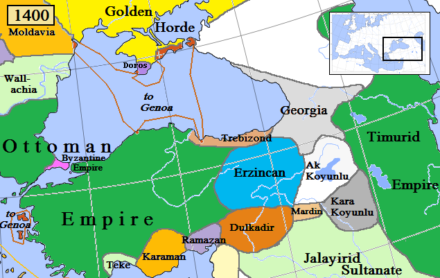
English: Trebizond and surrounding states in Anatolia/Caucasus in AD 1400.
(Partially based on Euratlas map of Europe, 1400, improved since Koza Yayınları Tarih Atlası sf.42; Kanaat Yayınları Tarih Atlası sf.28; Mutafian, Claude & Van Lauwe, Eric: Atlas historique de l'Arménie, Autrement publ., coll. «Atlas/Memoires», Paris 2001, ISBN 2-7467-0100-6 and since the graphic style of [1]) |
| Datum | |
| Žrědło | Swójske źěło |
| Awtor | Gabagool |
![[1]](http://vignette3.wikia.nocookie.net/genealogy/images/c/cf/Trebizond1300.png/revision/latest/thumbnail-down/width/340/height/340?cb=20110516182142)

|
Dieses Bild des Typs Historical map sollte als Vektorgrafik im SVG-Format neu erstellt werden. Vektorformate haben zahlreiche Vorteile; weitere Information unter Commons:Media for cleanup. Wenn dir eine SVG-Version dieses Bildes vorliegt, so lade diese bitte hoch. Nach dem Hochladen der Datei ist diese Vorlage auf der aktuellen Bildbeschreibungsseite durch die Vorlage {{Vector version available}}, oder kürzer {{Vva}}, zu ersetzen. Es ist empfohlen die neue SVG-Datei „Trebizond1400.svg“ zu nennen – dann benötigt die Vorlage vector version available (bzw. vva) keinen Parameter.
|
Licencěrowanje
Ja, awtor tutoho dźěła, wozjewjam je z tym pod slědowacej licencu:
Toś ta dataja jo pód licencu Creative Commons Attribution 3.0 Unported licencěrowana
- Smějoš:
- gromaźe wužywaś – źěło kopěrowaś, rozšyriś a dalej daś
- změšaś – aby źěło pśiměrił
- Pód slědujucymi wuměnjenjami:
- pśipokazanje – Musyš źěło pó wašni pśipokazaś, kótaruž awtor abo licencowaŕ jo pódał (ale nic pó wašni, až by se gódało, až wón tebje abo twójo wužywanje źěła schwalijo).
Stawizny dataje
Tłoc na datum/cas aby tencasna wersija se lodowała.
| datum/cas | Pśeglědowy wobraz | rozměry | Wužywaŕ | Komentar | |
|---|---|---|---|---|---|
| něntejšny | 6. apryla 2018, 13:03 | | 635x401 (107 kB) | Trecătorul răcit | Little changes since ''Koza Yayınları Tarih Atlası'' sf.42; ''Kanaat Yayınları Tarih Atlası'' sf.28; Mutafian, Claude & Van Lauwe, Eric: ''Atlas historique de l'Arménie'', Autrement publ., coll. «Atlas/Memoires», Paris 2001, ISBN 2-7467-0100-6 and since the graphic style of [http://vignette3.wikia.nocookie.net/genealogy/images/c/cf/Trebizond1300.png/revision/latest/thumbnail-down/width/340/height/340?cb=20110516182142] |
| 18. apryla 2009, 00:45 |  | 635x401 (82 kB) | Gabagool | {{Information |Description={{en|1=Trebizond and surrounding states in Anatolia/Caucasus in AD 1400. (Partially based on Euratlas map of Europe, 1400.)}} |Source=Own work by uploader |Author=Gabagool |Date=2009-04-18 |Permission= |other_ |
Datajowe wužywanje
Slědujucy bok wótkazujo na toś tu dataju:
Globalne wužywanje datajow
Slědujuce druge wikije wužywaju toś ten wobraz:
- Wužywanje na ast.wikipedia.org
- Wužywanje na azb.wikipedia.org
- Wužywanje na el.wikipedia.org
- Wužywanje na en.wikipedia.org
- Wužywanje na et.wikipedia.org
- Wužywanje na fiu-vro.wikipedia.org
- Wužywanje na fi.wikipedia.org
- Wužywanje na fr.wikipedia.org
- Wužywanje na gl.wikipedia.org
- Wužywanje na he.wikipedia.org
- Wužywanje na hsb.wikipedia.org
- Wužywanje na hu.wikipedia.org
- Komnénosz Teodóra iráni királyné
- Komnénosz Mária trapezunti császári hercegnő (1328–1408)
- Komnénosz Teodóra trapezunti császári hercegnő (?–1435)
- Komnénosz Mária bizánci császárné
- Márta iráni hercegnő
- Caterino Zeno
- Komnénosz Eudokia trapezunti császári hercegnő (IV. Alexiosz lánya)
- Crispo Miklós naxoszi herceg
- Crispo Jolán naxoszi hercegnő
- IV. Ióannész trapezunti császár
- Bagrationi N. trapezunti császárné
- Szeldzsukida Tamar grúz királyné
- Cicisvili Sziti grúz királyné
- II. Dávid trapezunti császár
- Komnénosz N. guriai fejedelemné
- Gabrasz Mária gotthiai hercegnő
- I. Sándor imereti király
- Szeldzsukida Gulsari imereti királyné
- Szeldzsukida Demeter imereti herceg
- Grúz Királyság
- Wužywanje na id.wikipedia.org
- Wužywanje na it.wikipedia.org
- Wužywanje na ka.wikipedia.org
- Wužywanje na lt.wikipedia.org
- Wužywanje na lv.wikipedia.org
- Wužywanje na pt.wikipedia.org
- Wužywanje na ru.wikipedia.org
- Wužywanje na sr.wikipedia.org
- Wužywanje na sv.wikipedia.org
- Wužywanje na tr.wikipedia.org
- Wužywanje na uk.wikipedia.org
Dalšne globalne wužywanje toś teje dataje pokazaś.