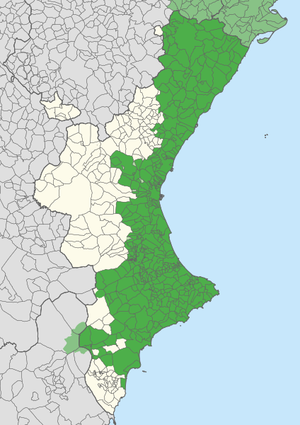
Dataja:Extensió del valencià al País Valencià.svg

Größe der PNG-Vorschau dieser SVG-Datei: 424 × 600 pikselow. Druge rozeznaśa: 170 × 240 pikselow | 339 × 480 pikselow | 543 × 768 pikselow | 724 × 1.024 pikselow | 1.448 × 2.048 pikselow | 744 × 1.052 pikselow.
Originalna dataja (dataja SVG, nominalnje: 744 × 1.052 piksele, wjelikosć dataje: 962 kB)
Stawizny dataje
Tłoc na datum/cas aby tencasna wersija se lodowała.
| datum/cas | Pśeglědowy wobraz | rozměry | Wužywaŕ | Komentar | |
|---|---|---|---|---|---|
| něntejšny | 21. apryla 2020, 12:27 |  | 744x1.052 (962 kB) | FogueraC | voltants |
| 20. apryla 2020, 17:24 |  | 744x1.052 (881 kB) | FogueraC | standard colors | |
| 18. maja 2007, 02:12 |  | 725x1.244 (1,53 MB) | Ebrenc | {{Cc-by-sa-2.5|Joan M. Borràs (ebrenc)}} Category:Maps of the Land of Valencia Category:Catalan language |
Datajowe wužywanje
Žedne boki njewótkazuju na toś tu dataju.
Globalne wužywanje datajow
Slědujuce druge wikije wužywaju toś ten wobraz:
- Wužywanje na ar.wikipedia.org
- Wužywanje na ast.wikipedia.org
- Wužywanje na ca.wikipedia.org
- Wužywanje na co.wikipedia.org
- Wužywanje na cs.wikipedia.org
- Wužywanje na de.wikipedia.org
- Wužywanje na en.wikipedia.org
- Wužywanje na es.wikipedia.org
- Comunidad Valenciana
- Discusión:Idiomas de España
- Vega Baja del Segura
- Predominio lingüístico
- Ley de uso y enseñanza del valenciano
- Portal:Comunidad Valenciana
- Idioma valenciano
- Usuario:Castellónenred/Página de Pruebas/PortalCV/Cultura y Tradiciones
- Portal:Comunidad Valenciana/Cultura y Tradiciones
- Cultura de la Comunidad Valenciana
- Usuario:MetroVal/Valenciano
- Usuario:JuananMJ/Taller
- Wužywanje na es.wikivoyage.org
- Wužywanje na eu.wikipedia.org
- Wužywanje na ext.wikipedia.org
- Wužywanje na fi.wikipedia.org
- Wužywanje na fr.wikipedia.org
- Wužywanje na gl.wikipedia.org
- Wužywanje na he.wikipedia.org
- Wužywanje na ia.wikipedia.org
- Wužywanje na id.wikipedia.org
- Wužywanje na ie.wikipedia.org
- Wužywanje na it.wikipedia.org
- Wužywanje na ja.wikipedia.org
- Wužywanje na lfn.wikipedia.org
Dalšne globalne wužywanje toś teje dataje pokazaś.
