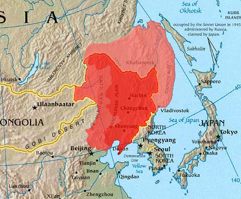
Dataja:Manchuria.png
Manchuria.png (480 × 395 pikselow, wjelikosć dataje: 440 kB, MIME-Typ: image/png)
Stawizny dataje
Tłoc na datum/cas aby tencasna wersija se lodowała.
| datum/cas | Pśeglědowy wobraz | rozměry | Wužywaŕ | Komentar | |
|---|---|---|---|---|---|
| něntejšny | 21. decembra 2023, 11:32 |  | 480x395 (440 kB) | Kwamikagami | Reverted to version as of 12:53, 21 March 2005 (UTC) -- last good version. Urup is not claimed by Japan. |
| 27. maja 2023, 17:26 |  | 480x395 (443 kB) | Minchuchui | Reverted to version as of 11:36, 19 February 2020 (UTC) | |
| 22. februara 2020, 13:26 |  | 480x395 (447 kB) | Wwbread | Reverted to version as of 20:27, 11 April 2019 (UTC) | |
| 19. februara 2020, 13:36 |  | 480x395 (443 kB) | Императоры России | Reverted to version as of 16:48, 19 September 2019 (UTC) | |
| 9. februara 2020, 20:47 |  | 480x395 (447 kB) | Wwbread | Reverted to version as of 20:27, 11 April 2019 (UTC). See discussion page. | |
| 19. septembra 2019, 18:48 |  | 480x395 (443 kB) | Императоры России | Kuye/Sakharin Island (库页岛) isn't included in Manchuria. | |
| 13. septembra 2019, 05:54 |  | 480x395 (447 kB) | Spodnikel | Reverted to version as of 20:27, 11 April 2019 (UTC) | |
| 4. septembra 2019, 14:14 |  | 480x395 (443 kB) | Императоры России | Reverted to version as of 12:30, 10 July 2018 (UTC) | |
| 11. apryla 2019, 22:27 |  | 480x395 (447 kB) | Wwbread | Kuye/Sakharin Island (库页岛) is a part of outer Manchuria. | |
| 10. julija 2018, 14:30 |  | 480x395 (443 kB) | Trecătorul răcit | Contrast |
Datajowe wužywanje
Slědujucy bok wótkazujo na toś tu dataju:
Globalne wužywanje datajow
Slědujuce druge wikije wužywaju toś ten wobraz:
- Wužywanje na als.wikipedia.org
- Wužywanje na ar.wikipedia.org
- Wužywanje na arz.wikipedia.org
- Wužywanje na ast.wikipedia.org
- Wužywanje na azb.wikipedia.org
- Wužywanje na az.wikipedia.org
- Wužywanje na be-tarask.wikipedia.org
- Wužywanje na be.wikipedia.org
- Wužywanje na bg.wikipedia.org
- Wužywanje na bn.wikipedia.org
- Wužywanje na br.wikipedia.org
- Wužywanje na ca.wikipedia.org
- Wužywanje na cs.wikipedia.org
- Wužywanje na de.wikipedia.org
- Wužywanje na el.wikipedia.org
- Wužywanje na el.wikiversity.org
- Wužywanje na en.wikipedia.org
- Wužywanje na en.wikiversity.org
- Wužywanje na eo.wikipedia.org
- Wužywanje na es.wikipedia.org
- Wužywanje na eu.wikipedia.org
- Wužywanje na fa.wikipedia.org
- Wužywanje na frr.wikipedia.org
- Wužywanje na fr.wikipedia.org
- Wužywanje na ga.wikipedia.org
- Wužywanje na gl.wikipedia.org
- Wužywanje na he.wikipedia.org
- Wužywanje na hi.wikipedia.org
- Wužywanje na hu.wikipedia.org
Dalšne globalne wužywanje toś teje dataje pokazaś.


