Dataja:Paris Metro Ligne 2.svg

Größe der PNG-Vorschau dieser SVG-Datei: 800 × 358 pikselow. Druge rozeznaśa: 320 × 143 pikselow | 640 × 286 pikselow | 1.024 × 458 pikselow | 1.280 × 572 pikselow | 2.560 × 1.144 pikselow | 850 × 380 pikselow.
Originalna dataja (dataja SVG, nominalnje: 850 × 380 piksele, wjelikosć dataje: 30 kB)
Zespominanje
| wopis |
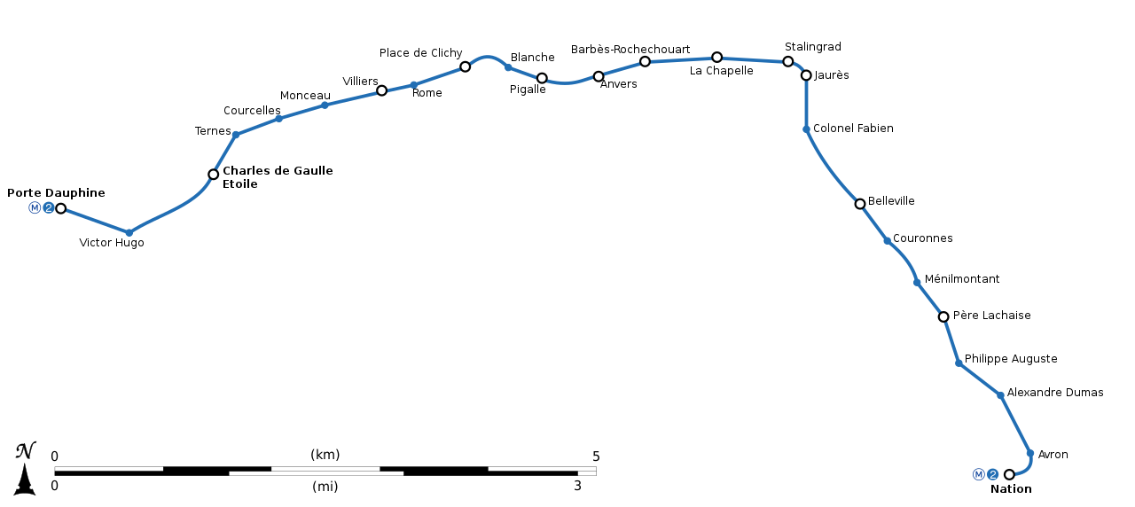
English: Geographically accurate path of Paris Métro Line 2. Français : Plan géographique de la ligne 2 du métro de Paris. |
||
| Datum | (UTC) | ||
| Žrědło | File:Paris-m2m6.svg by Controlling under licence CC0 | ||
| Awtor | Sémhur (diskusija) | ||
| Druge wersije toś teje dataje | |||
| SVG | Tuta wektorska grafika je so z Inkscape zdźěłała .
|
||
| Graphic Lab |

| Pozicija objekta | | Tónle a dalše wobrazy pola: OpenStreetMap |
|---|
Licencěrowanje
Ja, awtor tutoho dźěła, wozjewjam je z tym pod slědowacej licencu:
| Diese Datei wird unter der Creative-Commons-Lizenz „CC0 1.0 Verzicht auf das Copyright“ zur Verfügung gestellt. | |
| Die Person, die das Werk mit diesem Dokument verbunden hat, übergibt dieses weltweit der Gemeinfreiheit, indem sie alle Urheberrechte und damit verbundenen weiteren Rechte – im Rahmen der jeweils geltenden gesetzlichen Bestimmungen – aufgibt. Das Werk kann – selbst für kommerzielle Zwecke – kopiert, modifiziert und weiterverteilt werden, ohne hierfür um Erlaubnis bitten zu müssen.
|
Stawizny dataje
Tłoc na datum/cas aby tencasna wersija se lodowała.
| datum/cas | Pśeglědowy wobraz | rozměry | Wužywaŕ | Komentar | |
|---|---|---|---|---|---|
| něntejšny | 13. oktobra 2018, 01:24 | | 850x380 (30 kB) | AlexBurn44 | corres |
| 13. měrca 2015, 18:33 |  | 850x380 (30 kB) | Sémhur | + échelle ou pictogramme de la ligne | |
| 23. februara 2015, 14:59 |  | 850x380 (18 kB) | Sémhur | == {{int:filedesc}} == {{Information |Description={{Multilingual description |en= Geographically accurate path of Paris Métro Line 2. |fr= Plan géographique de la [[:fr:ligne 2 du métro de Paris|ligne 2 du métro de Paris... |
Datajowe wužywanje
Slědujucej 2 boka wótkazujotej na toś tu dataju:
Globalne wužywanje datajow
Slědujuce druge wikije wužywaju toś ten wobraz:
- Wužywanje na bs.wikipedia.org
- Wužywanje na cs.wikipedia.org
- Wužywanje na en.wikipedia.org
- Wužywanje na eo.wikipedia.org
- Wužywanje na fi.wikipedia.org
- Wužywanje na fr.wikipedia.org
- Wužywanje na id.wikipedia.org
- Wužywanje na it.wikipedia.org
- Wužywanje na ja.wikipedia.org
- Wužywanje na ko.wikipedia.org
- Wužywanje na lb.wikipedia.org
- Wužywanje na nl.wikipedia.org
- Wužywanje na no.wikipedia.org
- Wužywanje na oc.wikipedia.org
- Wužywanje na pl.wikipedia.org
- Wužywanje na ru.wikipedia.org
- Wužywanje na sk.wikipedia.org
- Wužywanje na www.wikidata.org