Dataja:WWI.png
Wjelikosć toś togo pśeglěda: 800 × 333 pikselow. Drugej rozeznaśi: 320 × 133 pikselow | 640 × 266 pikselow | 1.502 × 625 pikselow.
Originalna dataja (1.502 × 625 pikselow, wjelikosć dataje: 52 kB, MIME-Typ: image/png)
Zespominanje
| wopis |
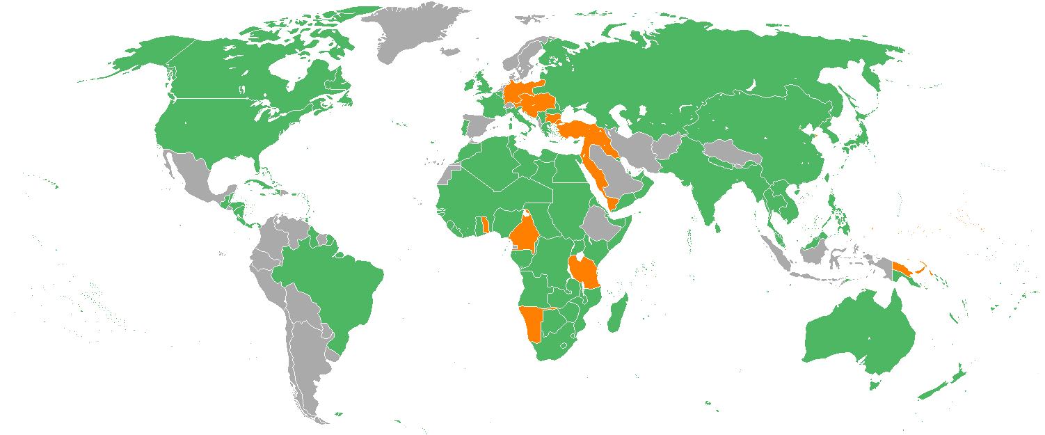
English: Map with the Participants in World War I:
Русский: Карта мира начала XX в. с границами альянсов:
Deutsch: Karte der Beteiligten des Ersten Weltkrieges:
|
| Datum | 22. decembra 2005 (Original-Hochladedatum) |
| Žrědło | Transferred from en.wikipedia to Commons. |
| Awtor | Helmandsare, Joaopais, El Jaber, Aivazovsky + Verschiedene (See below.) |
| Druge wersije toś teje dataje |
|


|
Dieses Bild des Typs Military map sollte als Vektorgrafik im SVG-Format neu erstellt werden. Vektorformate haben zahlreiche Vorteile; weitere Information unter Commons:Media for cleanup. Wenn dir eine SVG-Version dieses Bildes vorliegt, so lade diese bitte hoch. Nach dem Hochladen der Datei ist diese Vorlage auf der aktuellen Bildbeschreibungsseite durch die Vorlage {{Vector version available}}, oder kürzer {{Vva}}, zu ersetzen. Es ist empfohlen die neue SVG-Datei „WWI.svg“ zu nennen – dann benötigt die Vorlage vector version available (bzw. vva) keinen Parameter.
|
Licencěrowanje
Aivazovsky at the English Wikipedia, awtor tutoho dźěła, wozjewja je z tym pod slědowacej licencu:

|
Směće tutón dokument pod wuměnjenjemi licency GNU Free Documentation License, wersija 1.2 abo nowša wersija, wozjewjeneje wot załožby Free Software Foundation kopěrować, rozšěrjeć a/abo změnić; njejsu njezměnite wotrězki, njeje žadyn prědni a žadyn zadni wobalkowy tekst. Kopija licency je we wotrězku z titulom GNU Free Documentation License wobsahowana. |
| Toś ta dataja jo pód licencu Creative Commons Attribution-Share Alike 3.0 Unported licencěrowana | ||
| Pśipokazanje: Aivazovsky at the English Wikipedia | ||
| ||
| Tuta licencna marka je so tutej dataji jako dźěl licencneje aktualizacije přidała. |
Originalny protokol nagraśow
The original description page was here. All following user names refer to en.wikipedia.
- 2007-02-14 15:32 Aivazovsky 1357×628×8 (30657 bytes) Fixed northern islands of Russia and Norway, fixed borders of Russia's South Caucasus territory
- 2006-05-02 21:54 Helmandsare 1357×628×8 (30663 bytes)
- 2006-01-19 19:34 Joaopais 1357×628×8 (30415 bytes)
- 2006-01-15 12:12 El Jaber 1357×628×8 (45477 bytes) Map with the [[Participants in World War I]]: * <font color="green">''Green''</font>: [[Allies of World War I|Allies]] * <font color="red">''Red''</font>: [[Central Powers]] * <font color="yellow">''Yellow''</font>: [[Neutral Country|Neutral Countries]]
- 2005-12-22 00:53 Joaopais 1357×628×8 (30366 bytes) added Belize and the Guyanas (at the time British and French colonies)
- 2005-12-22 00:19 Joaopais 1357×628×8 (30365 bytes) Map with the [[Participants in World War I]]: * <font color="green">''Green''</font>: [[Allies of World War I|Allies]] * <font color="orange">''Orange''</font>: [[Axis Powers]]
Stawizny dataje
Tłoc na datum/cas aby tencasna wersija se lodowała.
| datum/cas | Pśeglědowy wobraz | rozměry | Wužywaŕ | Komentar | |
|---|---|---|---|---|---|
| něntejšny | 27. februara 2014, 20:19 | | 1.502x625 (52 kB) | Grachifan | major update |
| 27. februara 2014, 20:18 |  | 1.502x625 (60 kB) | Grachifan | major update | |
| 27. februara 2014, 20:17 |  | 1.502x625 (54 kB) | Grachifan | major update | |
| 31. měrca 2013, 05:28 |  | 1.357x628 (45 kB) | OgreBot | (BOT): Reverting to most recent version before archival | |
| 31. měrca 2013, 05:28 |  | 1.357x628 (30 kB) | OgreBot | (BOT): Uploading old version of file from en.wikipedia; originally uploaded on 2006-05-02 21:54:27 by Helmandsare | |
| 31. měrca 2013, 05:27 |  | 1.357x628 (30 kB) | OgreBot | (BOT): Uploading old version of file from en.wikipedia; originally uploaded on 2006-01-19 19:34:32 by Joaopais | |
| 31. měrca 2013, 05:27 |  | 1.357x628 (44 kB) | OgreBot | (BOT): Uploading old version of file from en.wikipedia; originally uploaded on 2006-01-15 12:12:07 by El Jaber | |
| 31. měrca 2013, 05:27 |  | 1.357x628 (30 kB) | OgreBot | (BOT): Uploading old version of file from en.wikipedia; originally uploaded on 2005-12-22 00:53:03 by Joaopais | |
| 31. měrca 2013, 05:27 |  | 1.357x628 (30 kB) | OgreBot | (BOT): Uploading old version of file from en.wikipedia; originally uploaded on 2005-12-22 00:19:12 by Joaopais | |
| 5. januara 2013, 01:42 |  | 1.357x628 (45 kB) | Tfts | marked Albania as a neutral state |
Datajowe wužywanje
Žedne boki njewótkazuju na toś tu dataju.
Globalne wužywanje datajow
Slědujuce druge wikije wužywaju toś ten wobraz:
- Wužywanje na als.wikipedia.org
- Wužywanje na ar.wikipedia.org
- Wužywanje na az.wikipedia.org
- Wužywanje na be.wikipedia.org
- Wužywanje na bg.wikipedia.org
- Wužywanje na ca.wikipedia.org
- Wužywanje na ceb.wikipedia.org
- Wužywanje na ce.wikipedia.org
- Wužywanje na da.wikipedia.org
- Wužywanje na de.wikipedia.org
- Wužywanje na en.wikipedia.org
- Wužywanje na eo.wikipedia.org
- Wužywanje na es.wikipedia.org
- Wužywanje na eu.wikipedia.org
- Wužywanje na fy.wikipedia.org
- Wužywanje na he.wikipedia.org
- Wužywanje na hr.wikipedia.org
- Wužywanje na hsb.wikipedia.org
- Wužywanje na hy.wikipedia.org
- Wužywanje na id.wikipedia.org
- Wužywanje na ja.wikipedia.org
- Wužywanje na kk.wikipedia.org
- Wužywanje na ko.wikipedia.org
- Wužywanje na la.wikipedia.org
- Wužywanje na lld.wikipedia.org
- Wužywanje na ms.wikipedia.org
- Wužywanje na nds.wikipedia.org
- Wužywanje na nl.wikipedia.org
- Wužywanje na pa.wikipedia.org
- Wužywanje na pl.wikipedia.org
- Wužywanje na pt.wikipedia.org
- Wužywanje na ro.wikipedia.org
- Wužywanje na ru.wikipedia.org
- Wužywanje na sh.wikipedia.org
Dalšne globalne wužywanje toś teje dataje pokazaś.